Accumulated Cyclone Energy (ACE) measures total hurricane season activity by combining storm intensity and duration. A major hurricane that lasts two weeks contributes far more than a brief tropical storm. NOAA uses seasonal ACE totals to classify years as Below Normal (<73), Near Normal (73–126), Above Normal (126–159), or Extremely Active (159+). More on ACE, plus a calculator →
Best-track data as of
Historical range based on 35 seasons since 1991.
| Landfall | |||||
|---|---|---|---|---|---|
| 7.2 | 37.0% | Cat 3 | 105 | Alabama (TS) est. | |
| 3.8 | 19.6% | TS | 60 | Fish Storm | |
| 2.2 | 11.5% | TS | 50 | Louisiana (TS) · Texas (TD) est. | |
| 1.5 | 7.7% | TS | 55 | Fish Storm | |
| 1.3 | 6.6% | TS | 45 | Fish Storm | |
| 1.3 | 6.6% | TS | 40 | Fish Storm | |
| 0.8 | 4.2% | TS | 50 | Texas (TS) est. | |
| 0.5 | 2.5% | TS | 35 | Puerto Rico (TD) est. | |
| 0.4 | 2.3% | TS | 40 | Fish Storm | |
| 0.4 | 2.1% | TS | 40 | Texas (TS) est. | |
| TOTAL | 19.5 | 100% | |||
est. Landfall estimated from the storm's preliminary track against coastlines. NHC confirms landfalls in its post-season Tropical Cyclone Report.
Compared with every season since 1991. Based on history only, not a forecast.
Best-track data as of
Historical range based on 35 seasons since 1991.
| Landfall | |||||
|---|---|---|---|---|---|
| 50.2 | 14.3% | Cat 5 | 155 | Sonora, Mexico (TS) est. | |
| 44.3 | 12.7% | Cat 5 | 140 | Fish Storm | |
| 31.5 | 9.0% | Cat 4 | 135 | Fish Storm | |
| 31.3 | 8.9% | Cat 4 | 125 | Fish Storm | |
| 26.9 | 7.7% | Cat 4 | 135 | Fish Storm | |
| 26.7 | 7.6% | Cat 3 | 105 | Baja California, Mexico (TS) est. | |
| 26.4 | 7.5% | Cat 5 | 140 | Fish Storm | |
| 24.6 | 7.0% | Cat 4 | 115 | Fish Storm | |
| 18.7 | 5.3% | Cat 2 | 90 | Fish Storm | |
| 16.3 | 4.7% | Cat 4 | 115 | Fish Storm | |
| 13.5 | 3.9% | Cat 2 | 85 | Fish Storm | |
| 13.3 | 3.8% | Cat 3 | 105 | Fish Storm | |
| 5.8 | 1.7% | Cat 3 | 100 | Fish Storm | |
Active Storm TD TS/SS Cat 1 Cat 2 Cat 3 Cat 4/5 Latest run of each model (UTC), shown as published. 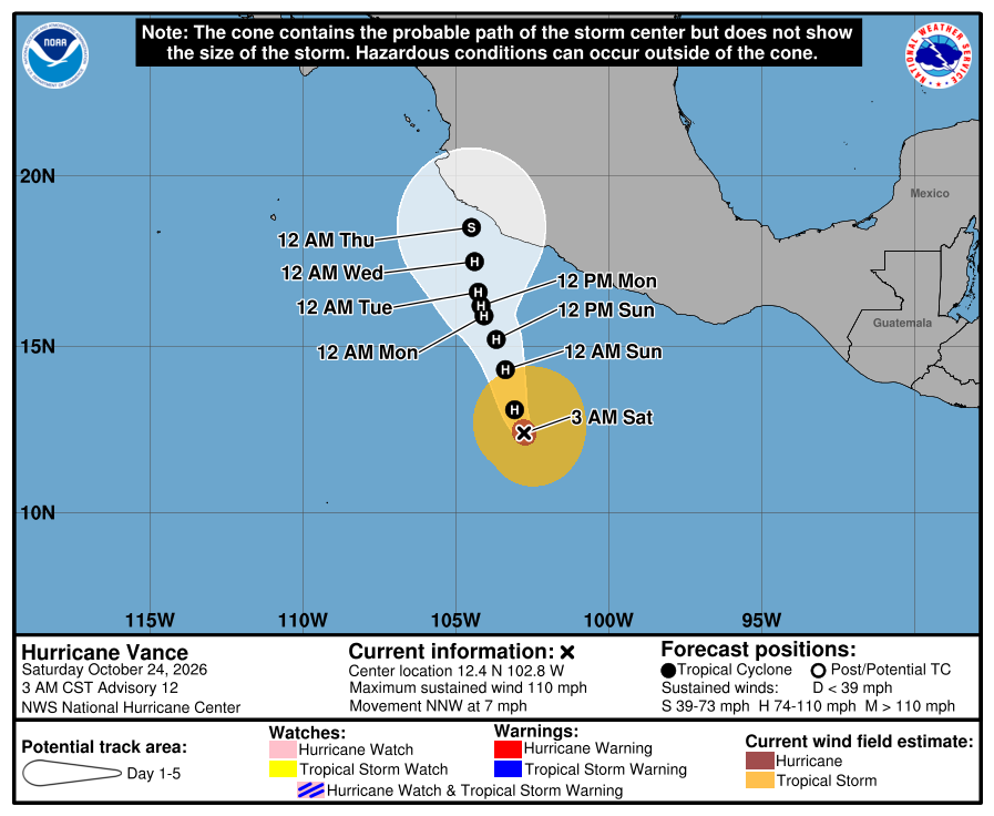 Forecast cone via NHC · advisory issued | |||||
| 5.6 | 1.6% | TS | 60 | Fish Storm | |
| 3.7 | 1.1% | TS | 55 | Fish Storm | |
| 3.5 | 1.0% | TS | 60 | Fish Storm | |
| 1.7 | 0.5% | TS | 40 | Fish Storm | |
| 1.6 | 0.5% | TS | 45 | Fish Storm | |
| 1.2 | 0.3% | TS | 40 | Fish Storm | |
| 0.8 | 0.2% | TS | 40 | Fish Storm | |
| 0.7 | 0.2% | TS | 35 | Fish Storm | |
| 0.7 | 0.2% | TS | 40 | Guerrero, Mexico (TD) est. | |
| 0.5 | 0.1% | TS | 45 | Fish Storm | |
| TOTAL | 349.7 | 100% | |||
est. Landfall estimated from the storm's preliminary track against coastlines. NHC confirms landfalls in its post-season Tropical Cyclone Report.
Compared with every season since 1991. Based on history only, not a forecast.
include_btk=True); updated continuously during active stormsACE (Accumulated Cyclone Energy) is calculated at 6-hourly synoptic times (0000/0600/1200/1800 UTC) for systems with status TS, HU, or SS and wind ≥34 kt — extratropical (EX) phases are excluded per NHC methodology. Formula: ACE = Σ(V²max) × 10⁻⁴. Categories use the Saffir-Simpson scale in knots.
Basin note: The East & Central Pacific tab combines both the Eastern Pacific (NHC, east of 140°W) and Central Pacific (CPHC, 140°W–180°) basins, consistent with the NOAA HURDAT2 Northeast & North Central Pacific dataset. NHC tracks these separately on their TCR pages (epac / cpac).
⚠️ This site is maintained by a hurricane data enthusiast — not a meteorologist, forecaster, or weather professional of any kind. I just love the data. All information is sourced directly from official NOAA/NHC databases. For official forecasts, watches, warnings, and life-safety information, always refer to the National Hurricane Center.
Page built October 24, 2026 at 12:44 UTC. Updates hourly during hurricane season. The data-as-of line above each basin's numbers shows how current the storm data is.
 Hurricane ACE Dashboard